
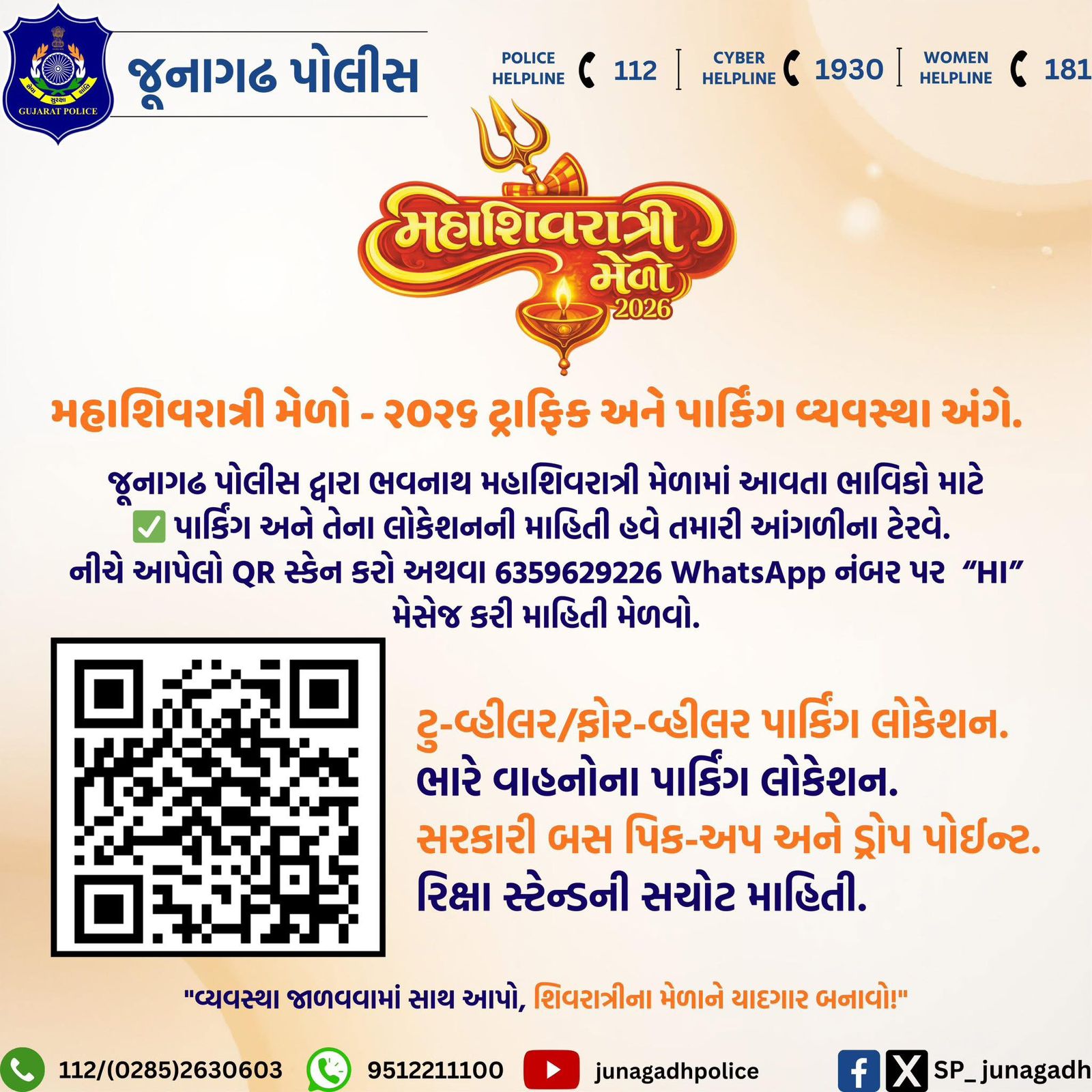
Mahashivratri is one of the biggest and most special festivals celebrated at Bhavnath Mahadev Temple in Junagadh. Every year, lakhs of devotees visit the temple during the Bhavnath Mahadev Mela, which makes proper traffic control and parking very important. To manage the large crowd and keep everyone safe, the Junagadh District Administration has released the Mahashivratri Mela 2026 Route Map & Traffic Management. This map clearly shows entry and exit routes, parking areas, road diversions and emergency facilities.
In this blog, we explain the traffic map, route names, parking arrangements and simple travel guidelines so devotees can plan their journey smoothly and enjoy a peaceful darshan without any trouble.
Helpline Number: For the convenience of devotees, the number 8401070010 has been made available.
Mahashivratri Mela 2026 – Route & Traffic Map
- Event Name: Bhavnath Mahadev Mela 2026
- Place: Shri Bhavnath Mahadev Temple, Junagadh
This route and traffic map is made to help devotees visit the mela easily and safely.
The map clearly shows:
- Which roads are open and which are closed
- Traffic diversion routes
- Parking areas for vehicles
- Emergency services locations
- Entry and exit routes to the mela ground
Emergency Helpline Number: 112
Police Control Room: 0285-26780
The Mahashivratri Mela is managed by the District Administration of Junagadh to ensure smooth traffic flow and safety for all devotees. Devotees are advised to follow the route map and police instructions for a peaceful and hassle-free darshan.
Route As Per Mahashivratri Mela Map
1. Green Routes: Allowed Roads
These roads are open for normal traffic during the mela.
- Junagadh City Main Road
- Girnar Taleti Road
- Bhavnath Temple Approach Road
- Ropeway Connecting Road
Note: Private cars, two-wheelers, autos and local vehicles can use these roads.
2. Red Routes: Closed/Restricted Roads
These roads are closed or have very limited entry, especially during busy hours.
- Inside Mela Ground Roads
- Roads in front of the Bhavnath Temple
- Narrow roads near the hill area
Note: Only emergency and authorised vehicles are allowed. Visitors should avoid these roads.
3. Orange Routes: Diversion Road
These are alternate roads made to avoid traffic jams.
- Junagadh Bypass Road
- Other Entry Roads of the City
- Outer Ring Road Routes
Note: Best for people coming from outside Junagadh.
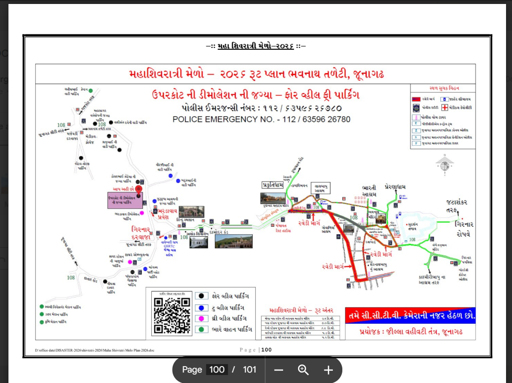
4. Emergency Vehicle Route
This route is only for emergency services.
- Used by ambulances, police and fire brigade
- Gives direct access to the temple and mela area
Note: Do not park or stop vehicles on this route.
Learn How to Reach Girnar Junagadh – By Train, Road & Air.
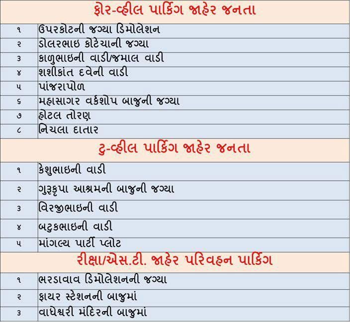
Parking Arrangements (As Per Map)
Four-Wheeler Parking
- Demolition of Uparkot
- Dolorbhai Kotecha Wadi
- Kalubhai’s Wadi
- Sasikanth Dave’s Wadi
- Panjarapol
- Mahasagar Side Workshop
- Hotel Toran
- Lower Datar
Two-Wheeler Parking
- Next to Gurukrupa Ashram
- Virajibhai’s Wadi
- Batukbhai’s Wadi
- Mangalya Party Plot
- Keshubhai’s Wadi
Auto/Rickshaw Parking: Free Parking
- Bhardwaw Demolition Place
- Next to fire station
For heavy vehicles
- Satisbhai Captain Wadi
- Swami Vivekananda Maidan
- Zafar Maidan
- Agriculture Maidan
GSRTC – Pickup/Drop Points
- Next to Vagheswari Temple
Important Note: Parking on the roadside is not allowed. Request to use only the designated parking areas.
Important Locations Shown On The Map
Bhavnath Mahadev Temple
A famous and holy temple of Lord Shiva, especially crowded during Mahashivratri.
Girnar Taleti
The starting point of Girnar Parvat is where pilgrims begin their temple journey.
Girnar Ropeway
A ropeway service that helps visitors reach the Ambaji Temple easily without climbing.
Mela Ground Area
The main area where the Bhavnath Mahadev Mela is held with stalls, tents and devotees.
Junagadh City Entry Points
The main roads through which people enter Junagadh City.
Hillside Route
A road that goes along the hills, mainly used by pilgrims and locals.
Bypass Road
An outer road that helps vehicles avoid city traffic and reach destinations faster.
Check the Girnar Mahashivratri Mela Safety Tips.
Public Safety & Emergency Facilities
The map also shows important places that help visitors stay safe and comfortable.
- Police Help Desk: For help, guidance and security support
- Control Rooms: For handling emergencies and coordination
- Medical Aid Centres: For first-aid and basic medical help
- Ambulance Points: For quick medical emergencies and transport
- Fire Brigade Stations: For fire safety and rescue services
- Drinking Water Points: For clean and safe drinking water
- Public Toilets: For visitor convenience
- Lost & Found Centres: To help find lost people or belongings
These facilities are placed at key locations to ensure a safe and smooth experience for everyone.

QR Code Feature on the Map
Scan the QR code to easily get:
- Live traffic updates
- Parking spots
- Route charges
- Emergency contact numbers
Important Instructions for Devotees
- Always follow the police instructions.
- Park your vehicle only in the marked parking areas.
- Heavy vehicles are not allowed on restricted roads.
- Emergency vehicles have the first priority.
- Try to visit during less busy hours if you can.
Frequently Asked Questions
Yes, a dedicated traffic and parking route map has been issued by the Junagadh administration.
Red routes are restricted or no-entry zones during the mela.
Yes, medical, police, ambulance, and fire services are available.
The Mahashivratri Mela arrangements are managed by the District Administration of Junagadh.
Yes, lost & found centres are available to help find lost people or belongings.
Yes, but only up to designated auto parking zones.